

Reducing warranty costs of Valtra's tractors with Machine Learning
This introductory post is part of a blog series about utilizing satellite data in data-driven business processes. More detailed posts will come, stay tuned!
Could you fly?
Ever dreamed of being able to fly (without the falling part)? What about flying really high and really fast? Hundreds of kilometers above the earth and covering a country in minutes?
I love to travel in this mode. Even COVID-19 can't stop me! The bad thing is I spend way too much of my employer's time zooming from Porvoo to Chicago to Mombasa to Nan Madol and so on. Today, I’ve seen Machu Pichu, Lake Victoria, and the Old Town of Prague. Also, I've been staring at spots in both Kirkkonummi and Karakorum. I can see almost any place at will. I can look several years back in time. All the time, I'm gathering impressions, images, and experience. Gathering data.
What am I? A satellite.
These days, anyone with a laptop and a decent internet connection can experience such things by using for instance Google Earth. This is a good way to get a glimpse of the volume, coverage and data constantly gathered by those eyes in the sky. They are exhaustively recording the light from the sun as it is reflected from the earth, creating information.
One more thing: Like anyone, I'm not limited to merely seeing stuff. I sense things. I see infrared wavelengths, so I can sense temperatures. I have a sense for seeing gases, greenhouse or other. I see humidity, moisture, and the intensity of vegetation. I'm very, very good at assessing distances: Good enough to map 3D surfaces. And I do not forget.
The universe of the available satellite data is, much as the universe itself, enormous in size. Massive publicly available archives reach decades back and the amount of data is constantly growing.
At various levels of spatial accuracy, geographical coverage, and different acquisition dates there is satellite data to be had. For example, Sentinel-2A satellites reach spatial resolution of 10 meters, while commercial satellites are providing resolutions of below half a meter. And this data is so much more than those (oh so) fascinating true color images (as the human eye sees things).
Finding value from space
Optical satellites measure, in addition to what humans can "see", a wide range of non-visible wavelengths providing for the detection and measurement of heat, vegetation health, particles in the atmosphere and more. The availability of several consecutive images of the exact same locations lends itself to change detection, i.e. mapping new buildings, changes at construction sites, or documenting changes in local and regional air quality.
Similarly, machine learning can be used with optical satellite images for instance for object detection, i.e. detecting undocumented buildings or for classifying the earth's surface according to needs (as to the land use, moisture, urban density and more).
Going radar
Unlike optical satellites, radar satellites actively send out signals , much like ships with sonar, to measure what's below. This data in turn produces very accurate measurements of elevation but also less easily defined characteristics of the ground.
Data from radar satellites is therefore useful in even better object detection (making detailed detection of e.g. ships or vehicles possible), bringing in a third dimension to what's described above; but also tracking changes small and big in the ground.
Has the ground around a construction site moved in any direction? What about minimal, millimeter-level movement of infrastructure such as bridges or dams? We can find out! And radar can even see through clouds, making the data even more consistent and reliable!
Satellite data can be used to improve and automate many types of monitoring and preventive maintenance processes. Here are a couple of concrete use cases:
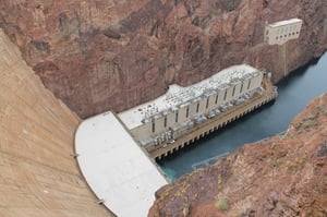 Hydro dam stability monitoring
Monitoring the structural health and stability of hydro dams is critical in ensuring safety and in maintaining the proper functioning of the dams.
However, it is also time-consuming and very expensive. Using satellite data to detect ground movement near dam structures can help to decrease regular asset inspection costs, reduce the manpower needed for regular asset inspections, and to identify any structural weaknesses. The method can reach the accuracy of millimeters. When combined with drone-based 3D-scanning, it is possible to automate monitoring large and otherwise inaccessible areas.
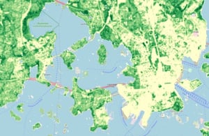 Forest monitoring for ensuring sustainable and certified methods
Monitoring forests and vegetation with satellite data is cost-efficient and reliable - and much faster than any other method.
Satellites enable analyzing forest degradation, deforestation and the overall health in many ways to ensure sustainable and certified methods are used in logging and forest work. Satellite data can be used to detect different tree species, estimate biomass, and assess damages caused by fire, storms or illegal logging.
Whatever the need, the main takeaway (apart from how cool all this and Google Earth in specific is) should be that satellite data as an additional data source is well worthy of consideration. Whether to bring additional data to existing reporting and descriptive processes, adding valuable features to existing AI work or tackling challenges by building satellite-based solutions from scratch, being able to fly is too valuable a skill not to be used.
At Advian, we can help you with this. 🛰️
Interested in improving your analytics with satellites?
Book a meeting with our experts 👇


